
Transport and heat loss of the Pacific Summer Water in the Arctic Chukchi Sea nothern slope: Mooring data analysis
單元大綱
-
-
The Chukchi Sea is the southernmost region of the Pacific Arctic Ocean. Warm Pacific Summer Water flows into the Chukchi Sea from the south through the Bering Strait from May to October (Figure 1) (Woodgate et al., 2005). Most of the Pacific Summer Water entering the Chukchi Sea is thought to be transported to the Barrow Canion in the northeastern Chukchi Sea (Itoh et al., 2013) and then further north to the Canadian Basin. This Pacific summer water whose temperatures above 0°C is related to the sea ice reduction in the Pacific sector of the Arctic Ocean (Timmerman et al., 2018). Therefore, many researches have been conducted to understand the transport pathways of the Pacific Summer Water into the Canadian Basin. Recent studies suggest that Pacific Summer Water passing through the Barrow Canyon is transported westward over the northeastern Chukchi Sea shelf margin along the Chukchi Slope Current (Figure 2) (Corlett and Pickart, 2017).
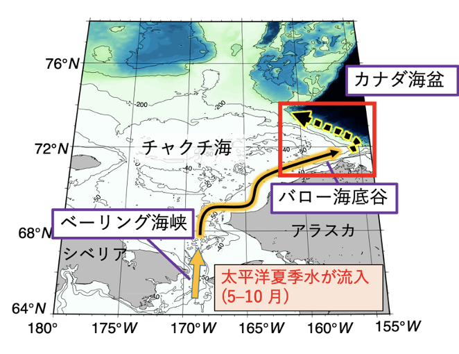
Figure 1: Pacific Summer Water flowing through the Chukchi Sea
太平洋夏季水が流入(5-10月): Pacific Summer Water inflow (May-October) チャクチ海: the Chukchi Sea ベーリング海峡: Bering Strait バロー海底谷: Barrow Canyon カナダ海盆: Canada Basin シベリア: Siberia アラスカ:Alaska
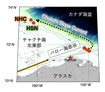
Figure 2: Northeastern part of the Chukchi Sea (within the red frame in Figure 1) Red circles: mooring stations, Red stars: Cape Barrow
-
-
-
Figure 3 shows the time-series variation of water temperature observed at station HSN/NHC on the Chukchi Sea northern slope. At this station, water masses classified as Pacific Summer Water were observed from July to March (colored areas in Figure 3). The mean sub-surface (30-60 m) temperatures of the water mass containing a large amount of Pacific summer water were 0.0°C in Period 1 (2003-2005) and 0.3°C in Period 2 (2015-2019) for the period indicated by the colored area. The current direction at the same station was northwestward throughout the year, and the mean sub-surface current velocity (northwestward: positive) during the coloring period was 15.4 cm s-1 in period 1 and 20.9 cm s-1 in period 2. It suggests that the Pacific summer water at station HSN/NHC on the Chukchi Sea northern slope is transported in a northwestward direction by the Chukchi Slope Current (Figure 4).
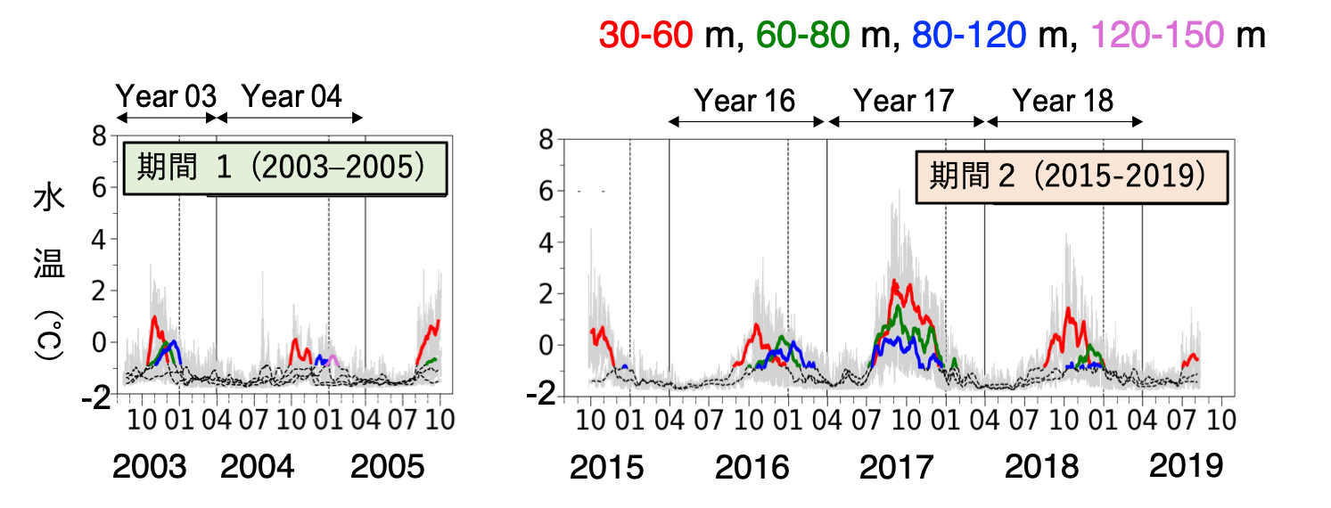
Figure 3: Time series variation of HSN/NHC water temperatures at stations
期間: Period 水温: Water Tempereture
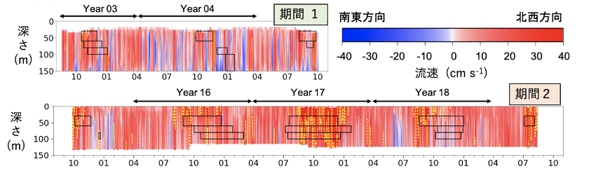
Figure 4. Northwestward (red) time series variation of current velocity (sea level - 150 m)
深さ: Depth 南東方向: Southeastward 北西方向: Northwestward
-
-
-
A lag correlation analysis, comparing the water temperature time-series in the Barrow Canion with the water temperature time-series at station HSN/NHC, was performed. The results indicate that it takes 7-61 days for Pacific Summer Water to be transported from the Barrow Canion to station HSN/NHC. Similarly, the mean sub-surface water temperature in the Barrow Canion was examined. Then it was found that the mean water temperature in the Barrow Canion was higher than that of the station HSN/NHC, and the water temperature decreased during the transport process. The decrease in water temperature was greater in period 2 (2015-2019) than in period 1 (2003-2005). (Figure 5)
Figure 5. The difference in mean water temperature between the Barrow Canion and station HSN/NHC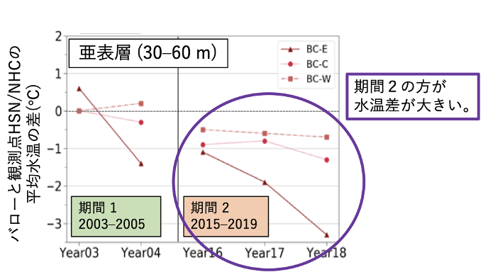
亜表層: sub-surface 期間2の方が水温差が大きい: the difference is greater in period 2 バローと観測点HSN/NHCの平均水温の差: the difference in mean water temperature between the Barrow Canion and station HSN/NHC
-
-
-
Mixing with low-temperature and low-salinity water in the surface layer is a contributing factor to the decrease in water temperature in the sub-surface layer of the northeastern shelf margin of the Chukchi Sea (see Figure 6). The vertical shear of stratification strength and current velocity, which are indicators of mixing strength, showed that mixing was more likely to occur in Period 2 (2015-2019) than in Period 1 (2003-2005). It suggests that mixing with surface water was greater in period 2, resulting in a greater drop in water temperature.
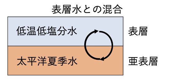
Figure 6. Mixing with surface water (schematic diagram)
表層水との混合: mixing with surface water 低温低塩分水: low-temperature and low-salinity water 太平洋夏季水: Pacific Summer Water 表層: surface layer 亜表層: sub-surface layer
-
