
Driving Deep Circulation and the Conveyor Belt Model."
セクションアウトライン
-
-
Why is there high salt differentiation in the Atlantic surface layer and low salt differentiation in the Pacific Ocean?
Remember the salinity ranges of the subtropical and subarctic zones.
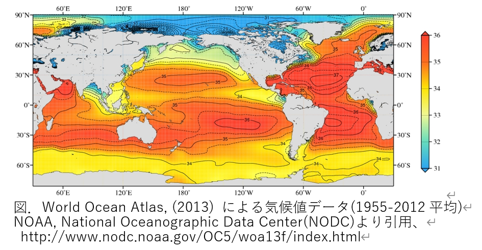
Climate value data (1955-2021 average) from Word Ocean Atlas.(2013), taken from NOAA National Oceanographic Data Center (NODC), http://www.nodc.noaa.gov/OC5/woa13f/index .html.
-
View (and download data for) surface to deep water profiles of temperature, salinity, oxygen, nutrients, etc. Select the parameters you wish to view and choose the resolution (1 or 1/4 degree) and water depth.
-
The Climate Agency's "Climate and Ocean Knowledge" site is extensive. You can also learn more here.
-
Deep circulation (thermohaline circulation)
(1) The water in the ocean, which is a fluid, has light water floating on the surface and heavier water sinking in the deeper part of the ocean. Water on the surface becomes denser as it cools. Surface water at high latitudes in the North Atlantic is highly saline. When that high-salinity water cools at the surface and becomes dense, it sinks to the depth of that density.
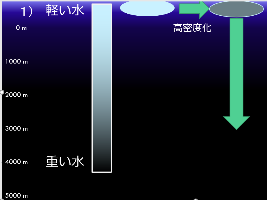
1)軽い水:light water 重い水:heavy water 高密度化:Higher density
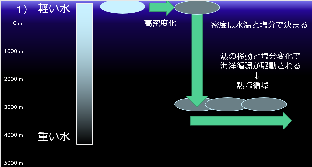
Densification can be continuous. Then there will be a continuous sinking to deeper depths. As the water is pushed down in this manner, deep water is formed and the oceanic general circulation begins. The density of seawater is determined by water temperature and salinity. In other words, the ocean circulation is driven by the transfer of heat to seawater and changes in salinity, which is also called the thermohaline circulation.
1)軽い水:light water 重い水:heavy water 高密度化:Higher density
密度は水温と塩分で決まる:Density is determined by water temperature and salinity.
熱の移動と塩分変化で海洋循環が駆動される:Heat transfer and salinity changes drive ocean circulation
熱塩循環:thermohaline circulation
Deep water submerged in the high latitudes of the North Atlantic moves southward, crosses the equator, and reaches the Southern Ocean.
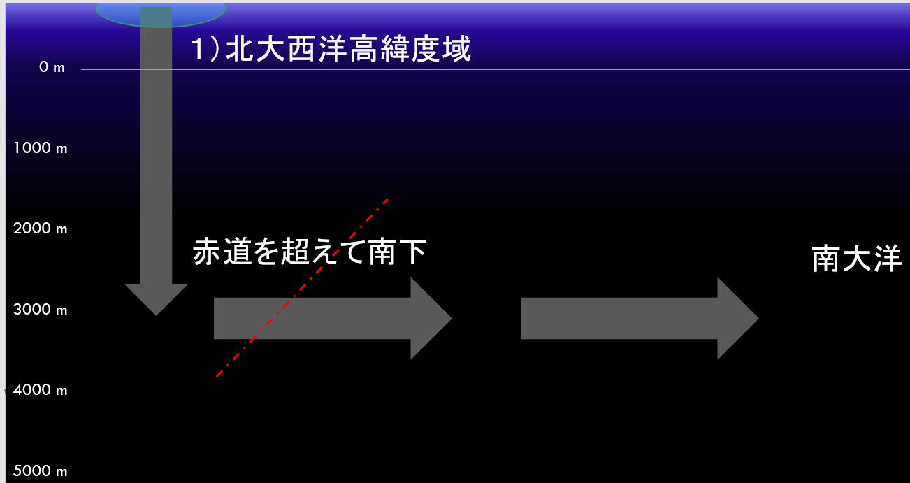
1)北大西洋高緯度域:(1) North Atlantic high latitudes
赤道を超えて南下:Southward across the equator
南大洋:South Pacific
Deep Atlantic Ocean water moving southward merges with the Antarctic Deep Reflow, which circles around the Antarctic Continent (see next figure). Even in Antarctica, the surface water is considerably cooled in winter, and is well mixed from the surface to the deeper layers. Furthermore, in the Antarctic Ocean, seawater freezes in the winter, forming ice. When seawater freezes, only the freshwater portion crystallizes. The salts it contains cannot enter the crystals and are ejected out of the ice. This cold, ultra-high-salinity water expelled from the ice is so heavy that it stoops down to the bottom of the Antarctic Ocean. It mixes with the water from the surrounding North Atlantic Ocean and falls to the bottom of the ocean. This is the Antarctic Bottom Water. The Antarctic Bottom Water crawls along the bottom of all the oceans as it moves northward.
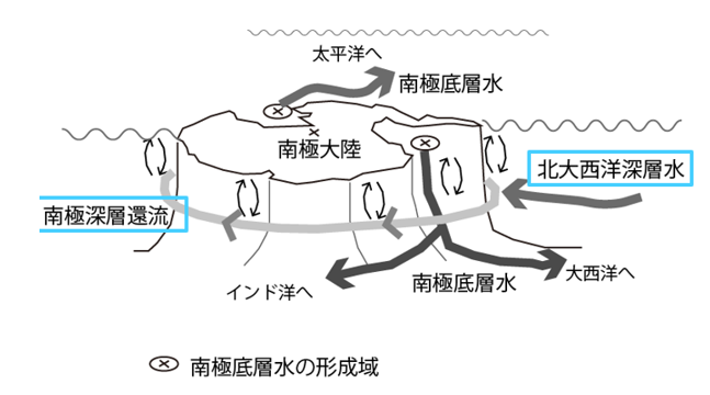
太平洋へ:To the Pacific Ocean 南極低層水:Antarctic low water
南極大陸:Antarctica 南極深層還流:Deep Antarctic Reflux
北大西洋深層水:North Atlantic Deep Water インド洋:Indian Ocean
南極底層水:Antarctic Bottom Water 大西洋へ:To the Atlantic Ocean
The figure below shows the flow of bottom water in the Pacific Ocean (taken from the Comprehensive Oceanographic Diagnostic Table on the JMA website). Bottom water is thought to flow along the topography of the ocean floor, undulating like a large river.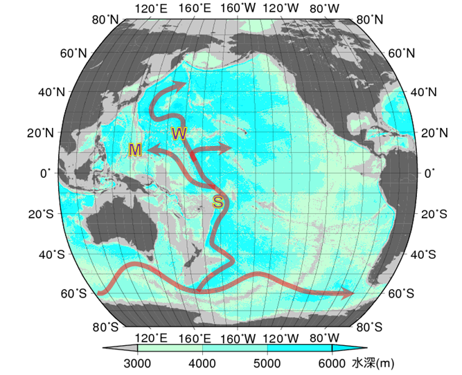
Antarctic Bottom Water moves northward along the bottom of the Atlantic, Indian, and Pacific Oceans. The figure below is a vertical cross section of water temperature in the Pacific Ocean, with the horizontal axis representing latitude and the vertical axis representing water depth. Water below 0.6°C from near Antarctica moves northward along the seafloor surface. The temperature of the bottom water, which is in contact with the seafloor surface, is gradually rising as it receives heat from the Earth's interior. When it reaches the North Pacific Ocean, the temperature is about 1.2°C. This water is called North Pacific Deep Water. This North Pacific Deep Water is said to reverse and move southward.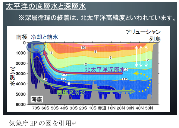
太平洋の底層水と深層水:Bottom and deep waters of the Pacific Ocean
深層循環の終着は、北大平洋高緯度といわれています:The terminus of the deep circulation is said to be at high northern Pacific latitudes.
南極:Antarctica 冷却と結氷:Cooling and freezing アリューシャン:Aleutian
列島:archipelago 水深:depth of water 北太平洋深層水:North Pacific Deep Water
周極底層水:circumpolar bottom water 海底:submarine
気候庁HPの図を引用:Adapted from a diagram on the Climate Agency's website
It is believed that the North Pacific Deep Water is brought to the surface slowly as it moves south, exchanging water with the middle layer. The surface water then promptly returns to the Atlantic Ocean.
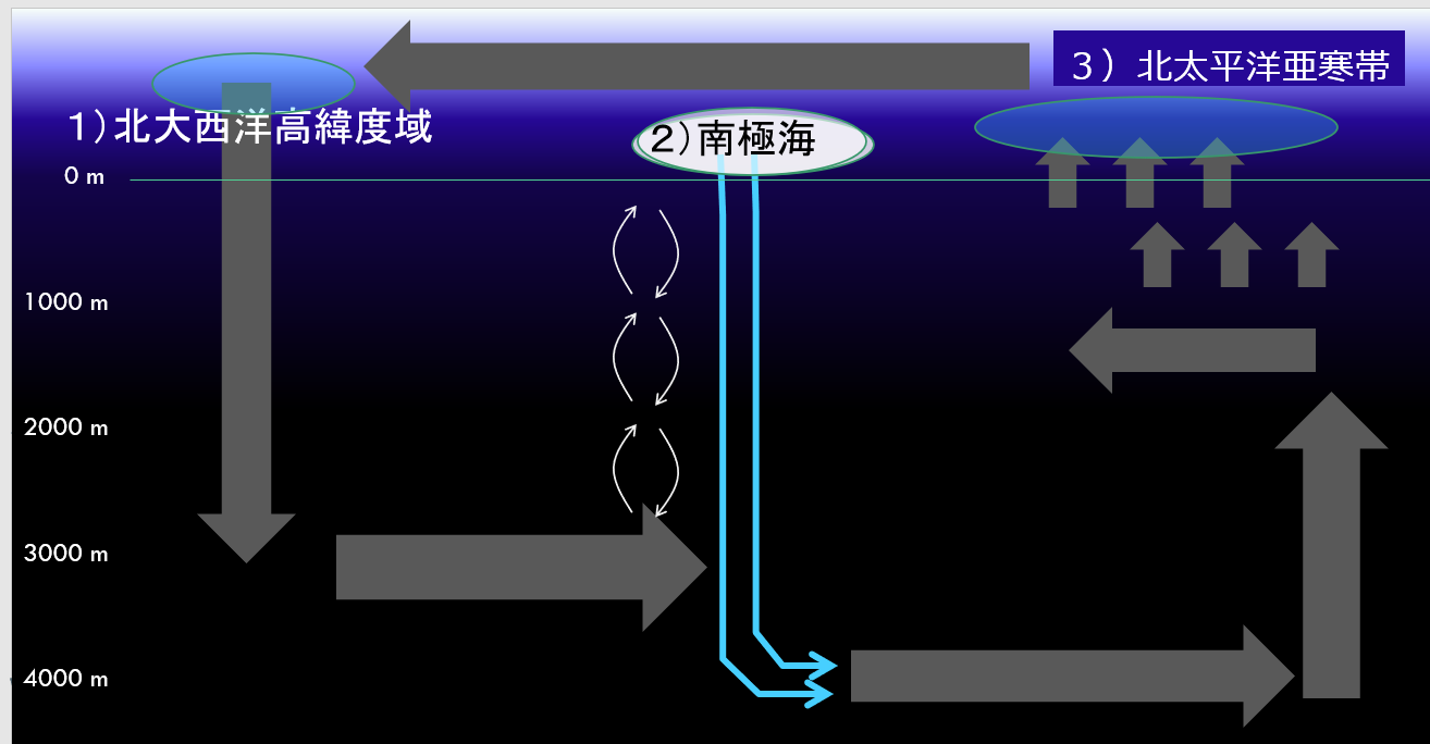
1)北大西洋高緯度域:1) North Atlantic High Latitude Domain
2)南極海:(2) Antarctic Ocean
3北太平洋亜寒帯:3 North Pacific subduction zone
-
conveyor belt model
The conveyor belt model, which represents such an oceanic general circulation, was proposed based on the idea that deep water being swept away one after another can be likened to a conveyor belt.
Ocean conveyor belt (area of heat release to the atmosphere equals the area of deep water formation) (JMA HP: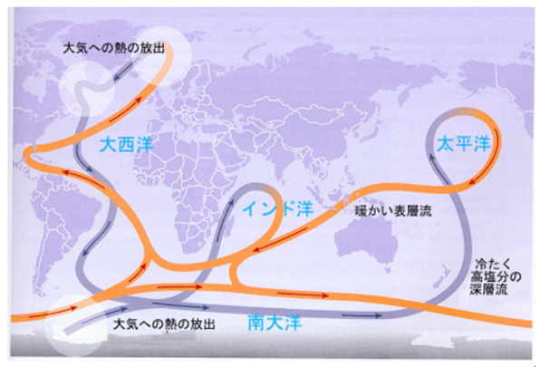
http://www.data.jma.go.jp/gmd/kaiyou/db/mar_env/knowledge/deep/deep) -
Vertical distribution of salinity
The vertical distribution of salinity in the North Atlantic (subarctic and arctic regions) to the North Pacific subarctic zone.
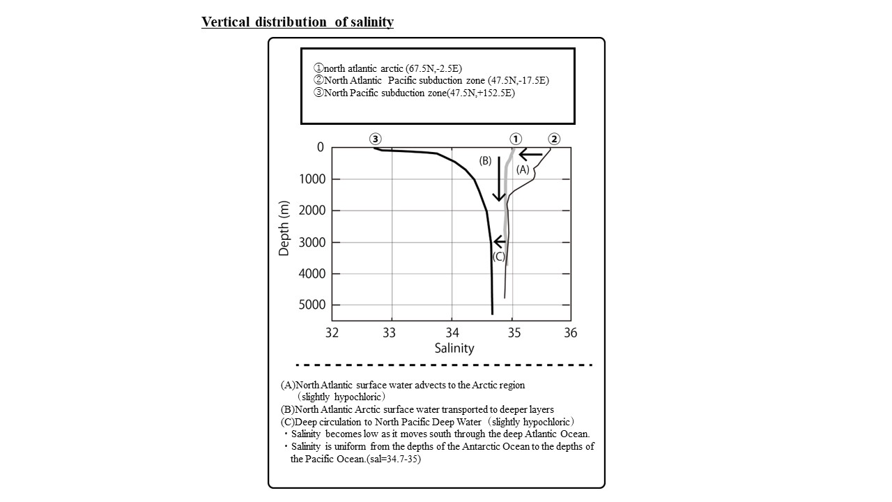
- In the North Atlantic, high-salinity surface water is transported from the subtropical to the subarctic to the arctic regions.
- In the middle of the process (②→①), the surface water becomes slightly hypochloritic (arrow A in the figure).
- The high-salinity surface water transported to the arctic region of the North Atlantic (1) is rapidly cooled and densified in winter and transported to deeper layers (arrow B in the figure).
- The North Atlantic Deep Water becomes slightly hypochloric (35‰ to 34.7‰) on its way southward through the Atlantic Ocean.
- The salinity of deep water in the Southern Ocean (Antarctic Ocean) and the Pacific Ocean (③) is uniform (34.7‰).
- The Pacific Ocean surface layer has low salinity, so a pronounced salinity dynamic layer appears from the surface to the middle layer (③).
Keep in mind the salt distribution in each ocean as shown in the figure above.
- In the North Atlantic, high-salinity surface water is transported from the subtropical to the subarctic to the arctic regions.
-